BAKU STATE UNIVERSITY JOURNAL of
EARTH SCIENCES & ENVIRONMENT
ISSN: 3006-8703 (ONLINE);
MODELING THE DEGREE OF ANTHROPOGENIC IMPACT ON THE LANDSCAPES OF THE NORTHEASTERN SLOPE OF THE GREATER CAUCASUS
Received: 25-May-2025 Accepted: 29-May-2025 Published: 12-Dec-2025 Read PDFDownload PDF
Rashad R. Sadullayev
DOI:
Abstract
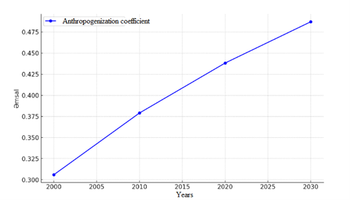
The anthropogenic transformation index (Lant) of landscapes is used to assess the degree of human impact on natural landscapes. Through this index, the intensity, spatial distribution, and dynamics of anthropogenic loads are determined. The Lant indicator is particularly useful for scientifically analyzing the impacts of urbanization, industrialization, agricultural activities, and transport infrastructures on landscapes, as well as for demonstrating these effects through visual models. This paper explores the determination and modeling of the degree of anthropogenic transformation of landscapes on the northeastern slope of the Greater Caucasus. GIS-based modeling not only reflects the spatial distribution of anthropogenic loads but also identifies the landscapes most and least affected, as well as high-risk zones. The research identifies landscape types impacted by anthropogenic influences based on Geographic Information Systems (GIS), satellite imagery, and field observations. These impacts are assessed using a scoring scale, and the results are presented in visual models. Maps illustrating the classification of natural landscapes based on anthropogenic loading and transformation levels have been created. The results are of significant importance for the formulation of sustainable natural resource management, landscape-ecological planning, and the optimization of anthropogenic loads in the region.