BAKU STATE UNIVERSITY JOURNAL of
EARTH SCIENCES & ENVIRONMENT
ISSN: 3006-8703 (ONLINE);
1D / 2D MODELING FOR INTEGRATED INTERPRETATION OF EM DATA: CASE STUDY PERIKSHKUL, AZERBAIJAN
Received: 10-Jun-2025 Accepted: 15-Jun-2025 Published: 12-Dec-2025 Read PDFDownload PDF
Avaz L. Mammadov; Ali G. Novruzov
DOI:
Abstract
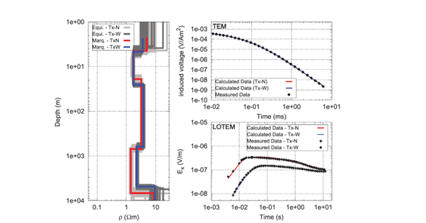
In this study, the geological structure of the Perishkul field in Azerbaijan was studied by 1D and 2D mod-eling of electromagnetic (EM) data. The main goal is to accurately determine the depth and resistivity increase of hydrocarbon-containing (oil-gas) formation. In the 1D inversion stage, the resistivity values of the subsurface layers are determined only as a function of depth (ρ = ρ(z)). Two types of inversion meth-ods were used:Marquardt (Damped Least Squares) and Occam’s Smoothness Constraint Inversion.TEM and LOTEM data were interpreted both separately and jointly. A five-layer model was identified in the study area: Layer 1: highly resistive (4–10 Ω m), ~10 m thick; conductive (1–2.5 Ω m), 25–35 m thick; at medium depth (30–800 m), ~4 Ω m; conductive (2–3 Ω m), 4000–6000 m thick; more resistive, approxi-mately 5000–7000 m deep. The increased resistivity of this last layer has been associated with hydro-carbon-bearing geological formation.